![](/images/other/stat-length.png)
![Randonnée Autre activité Saint-Martin (VS) - Pas de Lona - Photo](https://media.geolcdn.com/t/1900/400/ext.pjpeg?maxdim=2&url=https%3A%2F%2Fstatic1.geolcdn.com%2Fsiteimages%2Fupload%2Ffiles%2F1545311037marcheuse_200dpi.jpg)
Pas de Lona
Dgubler
Utilisateur
![Longueur](/images/other/stat-length.png)
Longueur
8,7 km
![Altitude max](https://static1.geolcdn.com/siteimages/upload/files/1508320355ic_sort_altitude_max_24dp.png)
Altitude max
2979 m
![Dénivelé positif](https://static1.geolcdn.com/siteimages/upload/files/1508320355ic_sort_den_pos_24dp.png)
Dénivelé positif
1034 m
![Km-Effort](/images/other/stat-length.png)
Km-Effort
19,6 km
![Altitude min](https://static1.geolcdn.com/siteimages/upload/files/1508320355ic_sort_altitude_min_24dp.png)
Altitude min
2114 m
![Dénivelé négatif](https://static1.geolcdn.com/siteimages/upload/files/1508320355ic_sort_den_neg_24dp.png)
Dénivelé négatif
179 m
![Boucle](https://static1.geolcdn.com/siteimages/upload/files/16400158638029165_repeat_loop_refresh_sync_direction_icon.png)
Boucle
Non
Date de création :
2014-12-11 00:00:00.0
Dernière modification :
2014-12-11 00:00:00.0
![Autre activité](https://static1.geolcdn.com/sitytour/trail-icons/900.png)
--
Difficulté : Inconnu
![Scannez ce code QR pour ouvrir la randonnée dans l'application SityTrail](https://capi.geolives.com/qq0zvz2zws4bq2lad0pu/sitytour/trails/18153/qr.png?size=200)
Application GPS de randonnée GRATUITE
À propos
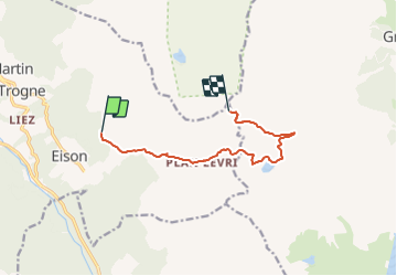
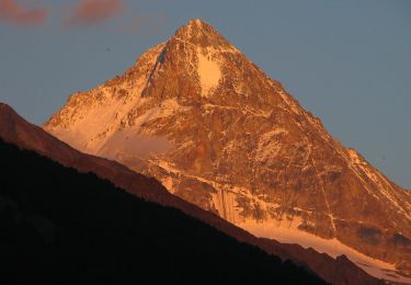
Randonnée Autre activité de 8,7 km à découvrir à Valais, Hérens, Saint-Martin (VS). Cette randonnée est proposée par Dgubler.
Description
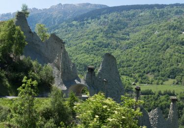
1er jour de l''excursion botanique d''Ecoréseau, le 4 août 2007. Magnifiques paysages entre les Chalets d''Eison et la cabane des Becs de Bosson
Localisation
Pays :
Suisse
Région :
Valais
Département/Province :
Hérens
Commune :
Saint-Martin (VS)
Localité :
Unknown
Départ:(Dec)
Départ:(UTM)
382370 ; 5112906 (32T) N.
Commentaires
Randonnées à proximité
![Randonnée A pied Hérémence - Euseigne - fixme - Photo](https://media.geolcdn.com/t/375/260/08722a44-5047-4239-9824-8775620384c2.jpeg&format=jpg&maxdim=2)
![A pied A pied](https://static1.geolcdn.com/sitytour/trail-icons/100.png)
Euseigne - fixme
A pied
Facile
Hérémence,
Valais,
Hérens,
Suisse
![](/images/other/stat-length.png)
3,2 km | 6,2 km-effort
1h 25min
![](https://static1.geolcdn.com/siteimages/upload/files/16400158638029165_repeat_loop_refresh_sync_direction_icon.png)
Non
![Randonnée A pied Hérémence - Euseigne - Hérémence - Photo](https://media.geolcdn.com/t/375/260/468f060f-ed15-4709-b3e8-a7c20409f4ab.jpeg&format=jpg&maxdim=2)
![A pied A pied](https://static1.geolcdn.com/sitytour/trail-icons/100.png)
Euseigne - Hérémence
A pied
Facile
Hérémence,
Valais,
Hérens,
Suisse
![](/images/other/stat-length.png)
5,2 km | 9,7 km-effort
2h 12min
![](https://static1.geolcdn.com/siteimages/upload/files/16400158638029165_repeat_loop_refresh_sync_direction_icon.png)
Non
![Randonnée A pied Evolène - Tour pédestre du Val d'Hérens - Photo](https://media.geolcdn.com/t/375/260/d60cf38c-77bf-4129-9294-d60e6b1dffc9.jpeg&format=jpg&maxdim=2)
![A pied A pied](https://static1.geolcdn.com/sitytour/trail-icons/100.png)
Tour pédestre du Val d'Hérens
A pied
Très difficile
Evolène,
Valais,
Hérens,
Suisse
![](/images/other/stat-length.png)
25 km | 49 km-effort
11h 5min
![](https://static1.geolcdn.com/siteimages/upload/files/16400158638029165_repeat_loop_refresh_sync_direction_icon.png)
Non
![Randonnée A pied Mont-Noble - La Combe - Nax - Photo](https://media.geolcdn.com/t/375/260/05728741-281c-4bbb-92b2-e33fe7322205.jpeg&format=jpg&maxdim=2)
![A pied A pied](https://static1.geolcdn.com/sitytour/trail-icons/100.png)
![Randonnée A pied Mont-Noble - Le Louché Lac - Col du Cou - Photo](https://media.geolcdn.com/t/375/260/d60cf38c-77bf-4129-9294-d60e6b1dffc9.jpeg&format=jpg&maxdim=2)
![A pied A pied](https://static1.geolcdn.com/sitytour/trail-icons/100.png)
Le Louché Lac - Col du Cou
A pied
Facile
Mont-Noble,
Valais,
Hérens,
Suisse
![](/images/other/stat-length.png)
3,7 km | 6,3 km-effort
1h 26min
![](https://static1.geolcdn.com/siteimages/upload/files/16400158638029165_repeat_loop_refresh_sync_direction_icon.png)
Non
![Randonnée A pied Mont-Noble - Le Louché-L'Ar du Tsan Lac (A) - Photo](https://media.geolcdn.com/t/375/260/d60cf38c-77bf-4129-9294-d60e6b1dffc9.jpeg&format=jpg&maxdim=2)
![A pied A pied](https://static1.geolcdn.com/sitytour/trail-icons/100.png)
Le Louché-L'Ar du Tsan Lac (A)
A pied
Facile
Mont-Noble,
Valais,
Hérens,
Suisse
![](/images/other/stat-length.png)
3,6 km | 5 km-effort
1h 8min
![](https://static1.geolcdn.com/siteimages/upload/files/16400158638029165_repeat_loop_refresh_sync_direction_icon.png)
Non
![Randonnée A pied Mont-Noble - L'Ar du Tsan - Le Louché Lac (B) - Photo](https://media.geolcdn.com/t/375/260/d60cf38c-77bf-4129-9294-d60e6b1dffc9.jpeg&format=jpg&maxdim=2)
![A pied A pied](https://static1.geolcdn.com/sitytour/trail-icons/100.png)
L'Ar du Tsan - Le Louché Lac (B)
A pied
Facile
Mont-Noble,
Valais,
Hérens,
Suisse
![](/images/other/stat-length.png)
4,1 km | 8 km-effort
1h 49min
![](https://static1.geolcdn.com/siteimages/upload/files/16400158638029165_repeat_loop_refresh_sync_direction_icon.png)
Non
![Randonnée A pied Evolène - Volvovron - L'A Vieille - Photo](https://media.geolcdn.com/t/375/260/5c03b540-8f8c-485d-804b-53ff835b3e8f.jpeg&format=jpg&maxdim=2)
![A pied A pied](https://static1.geolcdn.com/sitytour/trail-icons/100.png)
Volvovron - L'A Vieille
A pied
Facile
Evolène,
Valais,
Hérens,
Suisse
![](/images/other/stat-length.png)
4,2 km | 10,3 km-effort
2h 20min
![](https://static1.geolcdn.com/siteimages/upload/files/16400158638029165_repeat_loop_refresh_sync_direction_icon.png)
Non
![Randonnée A pied Evolène - Cotter - Volvovron - Photo](https://media.geolcdn.com/t/375/260/36ba09c3-e79b-4a55-a676-8e981d39bb91.jpeg&format=jpg&maxdim=2)
![A pied A pied](https://static1.geolcdn.com/sitytour/trail-icons/100.png)
Cotter - Volvovron
A pied
Facile
Evolène,
Valais,
Hérens,
Suisse
![](/images/other/stat-length.png)
3,4 km | 6,2 km-effort
1h 25min
![](https://static1.geolcdn.com/siteimages/upload/files/16400158638029165_repeat_loop_refresh_sync_direction_icon.png)
Non